
A.6.3. R.1.5. Zc.5.1. On a volunteer’s data sheet, those few characters told anyone reading it exactly where a penguin had been found on the St Kilda breakwater, usually to within about a metre. They look a bit like spreadsheet cell references. In a way, that’s what they are. The system behind them is one of the quiet reasons the long-term record on St Kilda breakwater penguins is worth so much.
This page replaces an old one from the colony’s monitoring programme, last archived in 2012, that explained how locations were recorded. We’ve rewritten it and filled the gaps from a study built on fieldwork in early 2007 that used the same system. The long-term study itself goes back to 1986, when Professor Mike Cullen of Monash University started visiting the wall; our page on the history of the St Kilda breakwater tells that story. Treat everything below as the method documented between roughly 2007 and 2012. We haven’t confirmed what the field protocol looks like today.
Painted letters every 20 metres along the wall
Letters were painted on the rocks exactly 20 metres apart, so every penguin sits inside a lettered section. The 2007 study described the markers as glued or sprayed on, counted 33 of them, and put the breakwater at about 660 metres long.
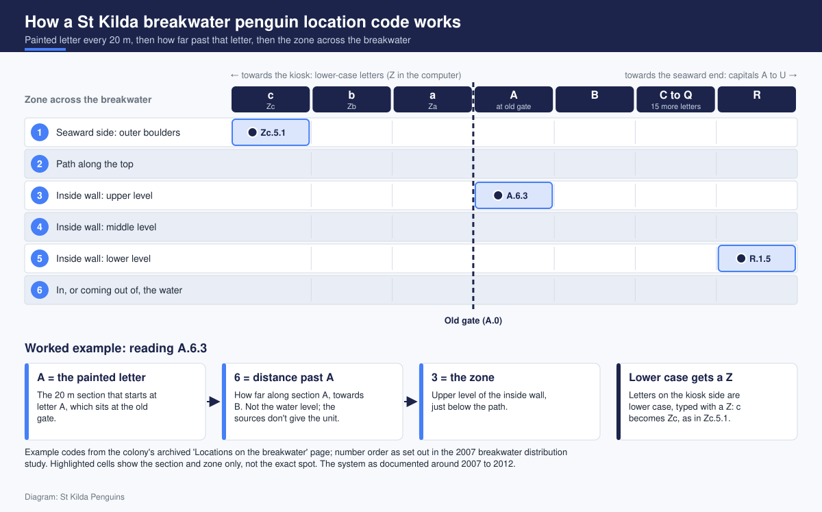
The lettering started at the old gate. That spot is A, or A.0 to be precise, and the capitals run out towards the seaward tip, finishing at U. Twenty gaps of 20 metres makes 400 metres, which matches the length the old monitoring page quoted for the breakwater. So that figure seems to describe the original lettered stretch rather than the whole wall.
Then the penguins moved. As the colony spread from the gate back towards the kiosk by the pier, the volunteers needed letters for ground the original scheme never covered. The answer was lower case on the other side of the gate: a, b, c and onwards, counting towards the kiosk, which sits at l. Capitals mean gate to sea. Lower case means gate to land. Twelve lower-case sections plus 21 capitals gives you the 33 markers the study counted.
Why some codes start with Z
Computers were the snag. The old page says only that every lower-case letter was given a Z in front “to make things easier on the computer”, so section c went into the records as Zc. Our reading is that plenty of spreadsheet and database tools treat c and C as the same thing when sorting or matching, and the Z stops the kiosk-end records blurring into the seaward ones. It’s a tidy fix. Slightly clunky to say out loud, mind you.
One more landmark matters. A new gate, built in November 2006 and working from January 2007, was recorded at e.7, partway along lower-case section e. It shrank the stretch open to the public, which matters for the research further down.
Six zones across the breakwater, from seaward rocks to water
A letter and a distance tell you how far along the wall a bird is. They don’t tell you whether it’s tucked into the boulders facing the open bay or sitting on the sheltered side. So the width of the breakwater was split into numbered zones as well:
- 1: the outer, seaward side
- 2: the path along the top
- 3, 4 and 5: three levels on the inside wall
- 6: in the water (the 2007 study’s figure says “in or coming out of water”)
The study’s figure lays these zones out in order across the width of the wall, which puts level 3 nearest the path and level 5 nearest the water.
Why number the seaward side at all? Penguins occasionally try it, and they have a rough time. The 2007 study noted that few penguins nest on that side because it’s exposed to wave action. The colony’s 2009-10 season report tells the story of one pair on the outer seawall at letter N that was washed out twice by storms before raising a single chick on the third attempt. In code, that pair lived at N, something, 1, and anyone reading the records later could see how exposed their spot was.
How to read a code like A.6.3
Every record has three parts, separated by full stops:
- The letter: which 20-metre section the bird is in.
- The first number: how far along the section from that letter.
- The last number: the zone across the breakwater.
So A.6.3 sits in section A, at distance mark 6 past the letter, on level 3 of the inside wall. R.1.5 is at mark 1, just beyond letter R, low on the inside wall at level 5. Zc.5.1 is at mark 5 in lower-case section c, out on the seaward side, on the kiosk side of the old gate.
There’s a small trap here, and the old page walks straight into it. It explains that a penguin in the water is recorded as level 6, then offers A.6.3 as an example, which makes it tempting to read that 6 as the water. It isn’t. The 2007 study spells out the order: the letter, then a decimal place for how far along, then another for the zone, with A.8.3 as its own worked example. The gate positions, A.0 and e.7, back this up. Neither source spells out the unit for that middle figure, so we won’t guess between metres and tenths of a section. The study simply says that, recorded this way, a penguin’s position is known to within roughly a metre.
Why exact locations matter for St Kilda breakwater penguins
A microchip tells you who a penguin is. The location tells you where it lives, and that half of the record answers most of the interesting questions.
Repeat captures and individual histories
When the same microchipped bird turns up at the same letter season after season, researchers can piece together where it nested and how often it was handled. The 2009-10 report noticed that some penguins around letters D, J, K, L and M had been caught as many as 11 times in a single season. Its author asked whether those birds had shallower burrows or were losing their fear of people, a question worth answering for a colony that should stay as wild as possible. You can only spot a pattern like that if every capture carries a location.
Nest-site fidelity
Little penguins tend to return to the same colonies and nesting sites over successive years, as the little penguin species account on Wikipedia summarises. On a wall where one boulder looks much like the next, a coded location is what shows a bird is back in last year’s cavity, not just somewhere near the bend. We’ve also written about how a penguin finds its own nest cavity after dark.
Breeding-site counts and the public stretch
Locations also turn scattered sightings into maps. In 2009-10 the breakwater was shared between three teams, each checking a similar distance, and the report counted 111 breeding sites in the area closest to the kiosk, 87 in the second area and 63 in the third. The 2007 study of where penguins live along the breakwater compared letter sections inside and outside the public area, finding significantly fewer penguins per 20-metre section where the public could walk. Numbers were consistently high at N, O, P and Q, possibly because the wall widens around the bend.
None of that works without the grid. The study noted that records go back to 1986, but the current mapping system only arrived after 2001, and many earlier locations were descriptive and hard to convert. Honestly, we reckon the tin of paint did as much for this colony’s science as any gadget. A microchip reader is clever. A letter on a rock, exactly 20 metres from the last one, is what makes years of sightings comparable.
Where the grid fits in the monitoring year
The colony’s research year doesn’t follow the calendar. As the old page explained it, the St Kilda penguin year runs May to April, ending once the adults have finished moulting and the chicks have all fledged. Our penguin calendar and seasonal life cycle page walks through each part of it.
May and June were the desk months. The research team worked through the year’s accumulated data, wrote up a report on the season, and updated the records for every tracked penguin. That’s where clean location codes earn their keep: twelve months of night work has to line up by bird and by place.
The old page was candid about the gaps. Some penguins were microchipped and never seen again. Others went missing for years before turning up. The 2009-10 report mentions still catching birds first banded in 1993. A bird that vanishes for several seasons and reappears at the same letter tells a very different story from one that resurfaces at the far end of the wall, and only the location record shows which you’re looking at.
Our piece on the volunteer monitoring and banding work at St Kilda covers what a monitoring night involves, and how researchers tell individual penguins apart explains the identification half of the record.
What you can notice from the viewing platform
You won’t be reading location codes from the boardwalk, and nobody should go hunting for painted letters on the rocks. Little penguins are protected under the Wildlife Act 1975, and Parks Victoria’s St Kilda Pier and Breakwater page is clear that flash photography, bright lights and phone torches are not permitted. Viewing today is run by Phillip Island Nature Parks as free, ticketed sessions from a dedicated platform, and the St Kilda penguin viewing page at penguins.org.au has the booking details.
What you can do is read the breakwater the way the volunteers did. Watch the water first, the zone 6 of the old records, then follow the birds as they come ashore and work their way up the rocks. Notice which side of the wall is sheltered and which side takes the swell, and you’ll see why so few nests were logged on the seaward face. If you do catch sight of a painted letter on a rock, you’ll know it marks the start of a 20-metre section, though we can’t promise any particular marker is visible from the platform today.
Frequently asked questions
What does a code like R.1.5 mean?
R is the 20-metre section, 1 shows the bird was just past the painted R, and 5 is the zone, the lowest of the three levels on the inside wall. Under this system, that’s a penguin low on the sheltered side, well out towards the seaward end.
Why are some letters lower case?
The original capitals ran from the old gate to the seaward end. When penguins spread towards the kiosk, the new sections there got lower-case letters, typed with a Z in front, so c became Zc.
Is this exactly how monitoring works today?
We can’t say for certain. Everything here comes from the colony’s archived monitoring page, its 2009-10 season report and the 2007 distribution study. Present-day methods may differ, so treat this as how it was done then.
Can I see the painted letters from the boardwalk?
Possibly, but we haven’t checked which markers can be seen from today’s viewing platform, so don’t count on it. Stay on the boardwalk either way. The rocks are penguin habitat, and somewhere in them is a bird with a code like A.6.3 against its name.